
Hydrologic cycle in a land
We assess regional hydrological cycle in land by using satellite data, geographical information system, AMeDAS data and so on. The relationship between cause and results on this phenomenon is so complicated. Therefore we are studying the whole system by investigating each process and mutual relationship. The followings are more detailed items.
- Assesment of flux.
- Assesment of snowmelt.(Snow change simulation)
- Assesment of evapotranspiration.
- Assesment of underground water.
- Prediction of runoff.(Runoff simulation)
The whole system involve many subsystem. For example, assessment of distribution and activity of vegetation can be expanded it into probrems on CO2 balance and assessment of evapotranspiration. For this purpose we deal with various study area for analysis which expands from a basin of one dam to the whole region in the Tohoku district and in the Korean Peninsula.
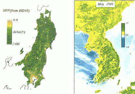
(Left) : Net primary product in the Tohoku
district (NOAA satellite data,
1989).
(Right) : Distribution of vegetation activity
in the Korean Peninsula.
Impacts of Water on Climate Change
Hydrologic cycle is affected by climate change involving global warming. Some reports mention that Japan will have higher extreme rainfall and heavier flood and slope failures. To prepare those higher risks, we have to consider future infrastructures for adaptation. Future risks for the flood and the slope failure are evaluated using numerical simulations with general circular models (GCMs). The results are also used for economic damages with a numerical risk map. The study areas are mainly whole Japan and Thai mountainous regions. These researches can be applied to urbanization problems and efficient infrastructure design.
- Evaluation of economic damages for flooding in a whole Japan.
- Prediction of landslide using remote sensing and hydrological simulation.
- Assessment of groundwater resources on sea level rise.
- Snow and ice water resources under global warming
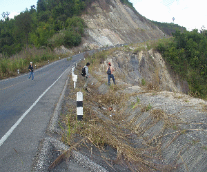
Landslide in the northern Thailand.
Ecohydrology
Watershed and river environments influence ecosystem. We are quantitatively proposing more suitable water environment in view of ecosystem through water using remote sensing technologies, hydrologic numerical simulation, and field survey. Our analysis scale is a basin-wide scale and we utilize not only geographical information system (GIS) frequently but also laboratory experiments. Species and genetic diversities are evaluated from the basin environment such as hydrologic values, landuse, and geology. Interaction between water and water creatures should be quantitatively solved for a better watershed.
- Habitat estimation of water creatures and insects.
- Relationship between river strucutures and species diversity.
- Evaluation of bio-diversity and genetic diversity in a basin.
- Phytoremediation.
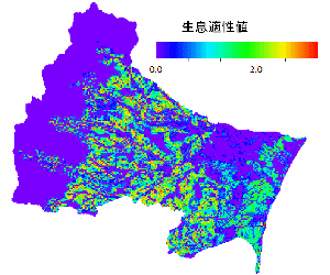
Habitat estimation of firefly in Natori River basin.
Contribution to Developing Countries
There are many unknown phenomena for water environment in developing countries, which is much different from Japan, and we are challenging to solve those phenomena and water problems in developing countries. For example, the Mekong River generates seasonal inundation damaging infrastructures but providing many benefits. Bolivia will have less water resources after glacier disappearance caused by global warming and new water resources should be found in near future. Integrated and comprehensive evaluation supports the national ground design in view of water issues. Remote sensing technologies and simulation are powerful tools for discussing above problems.
- Study on the Mekong River flood.
- Flood mitigation in Thailand.
- Landslide assessment in Thailand.
- Glacier retreat in Bolivia.
- Water resource decreases in Sri Lanka.
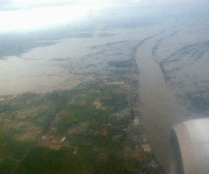
Mekong River inundation in Cambodia.
Graduation Theses (last 3 years)
- 2015
- Estimation of flood and storm surge complex disaster for adaptation (AKIMA, Masahiro)
- Relationship between Net Primary Production and watershed development in floodplain (HIRAGA, Yusuke)
- Estimation of periphyton in the Natori River Basin using a hydrological model (WATANABE, Kengo)
- Relationship between Net Primary Production and watershed development in floodplain (HIRAGA, Yusuke)
- 2016
- Relationship between probablic rainfall and discharge using DAD analysis (SUGAWARA, Yuta)
- Evaluation of wood yields in whole Japan (SUKEGAWA, Yuto)
- Characteristics of distribution on frequent inundation area in metropolitan cities (NAKAGUCHI, Kota)
- Evaluation of wood yields in whole Japan (SUKEGAWA, Yuto)
- 2017
- Evaluation of river use by text analysis on Instagram data (ANZAI, Satoshi)
- Dynamics of heat, water, CO2 fluxes over the heterogeneous land surface (KON, Masafumi)
- The impact of individual plants on CO2 flux in surface boundary layer (SAKAI, Nanami)
- Estimation of the damage cost on compound water related disaster and its adaptation (TANAKA, Yukako)
- Dynamics of heat, water, CO2 fluxes over the heterogeneous land surface (KON, Masafumi)
Master Theses (last 3 years)
- 2015
- Estimation of landslide in Thailand under climate change (INOUE, Naotatsu)
- 2016
- Ecaluation of river interests using social scinentific analysis and SNS analysis (KAWAMORITA, Satoshi)
- Time series of benthic animals after slit making of check dams (HAYASHI, Tatsuya)
- Assessment of runoff and meteological factors by a distributed runoff model (Gao, Lei)
- Analysis on glacier retreat using morphological data and glacier dynamic model (YOSHIZAWA, Kazuki)
- Quality evaluation of turbulence flux using uncertainty analysis (KOYAMA, Shunpei) (GSES)
- Time series of benthic animals after slit making of check dams (HAYASHI, Tatsuya)
- 2017
- Analysis of the water-related compound disaster risk under climate change (AKIMA, Masahiro)
- Evaluation of mutual effect of the the storage of the subsurface water and snow in basin areas (SAITO, Masahito)
- Impact of watershed development on environment of the floodplain in tropical monsoon region (HIRAGA, Yusuke)
- Relationship between environmental DNA of invertebrate species and benthic species in Natori River Basin (UCHIDA, Noriko)
- Estimation of periphyton dynamics in a temperate catchment using a distributed nutrient-runoff model (WATANABE, Kengo)
- Environmental assessment and model development of arsenic concentration in surface water in the Mekong River Basin, Cambodia (SATO, Iku) (GSES)
- Proposing the flood risk index in view of forest and climate change(Pharakonkham Sengphrachanh) (GSES)
- Evaluation of mutual effect of the the storage of the subsurface water and snow in basin areas (SAITO, Masahito)
Dissertations
- 2014
- Hazard evalulation and future projection of shallow landslide in the tropic monsoon region (ONO, Keisuke)
- 2015
- An Integrated Study of Water Resources and Climate Change Impacts in the Upper Chao Phraya River Basin in Thailand(Pratoomchai Weerayuth)
- 2016
- Relationship between agricultural production and flood inundation in the lower Mekong Region (AMANO, Ayako)
Back to
Labs
← Structural Design Engineering | Here | Enviromental Hydrodynamics →
